![]()
Main Menu ·
Search ·
Current Issue · Contact · Archives · Centennial · Letters to the Editor · FAQs
![]()
Main Menu ·
Search ·
Current Issue · Contact · Archives · Centennial · Letters to the Editor · FAQs
|
|
|
The collection has strong holdings of less ornamental but useful nineteenth- and twentieth-century nautical charts of United States and world waters.
|
 |
Main Menu ·
Search · Current Issue · Contact · Archives · Centennial · Letters to the Editor · FAQs
![]()

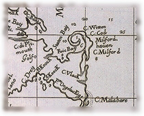
 Detail of an earlier chart for mariners, showing the location of ports and coastal features and providing rhumb lines and other navigational aids. Drawn on vellum by Salvator Oliva in Marseilles, it is part of a unique, manuscript atlas of several charts made in 1620. Oliva provides in this detail a profile of his own Marseilles, suggesting how it might appear to sailors approaching by sea. Charts of this sort were secret documents, crucial to trade, and usually were not published, says Cobb. This highly decorative example may have gone to sea but was probably kept safe at home for reference.