![]()
Main Menu ·
Search ·
Current Issue · Contact · Archives · Centennial · Letters to the Editor · FAQs
![]()
Main Menu ·
Search ·
Current Issue · Contact · Archives · Centennial · Letters to the Editor · FAQs
|
Each year Philip Sadler takes his "Celestial Navigation" students out into Boston Harbor and asks them to navigate their way back home. They prepare using facsimiles of this old chart and compare what it shows to present-day conditions. New channels have been opened. The shape of the city has changed entirely. Islands have gone and come. (Yet many of the islands shown on this chart have just become part of the national park system.)
|
|
|
|
|
 |
Main Menu ·
Search · Current Issue · Contact · Archives · Centennial · Letters to the Editor · FAQs
![]()
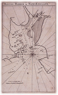 The collection abounds in local and regional maps. Left: A detail from the first printed chart of Boston Harbor, as it appears in The English Pilot: The Fourth Book, published by John Thornton and Richard Mount in London in 1698. This atlas is called a portolano or rutter; its charts are accompanied by detailed sailing directions and profiles of coastal land masses, "shewing the courses and distances from one place to another, the ebbing and flowing of the sea, the setting of the tides and currents, &c."
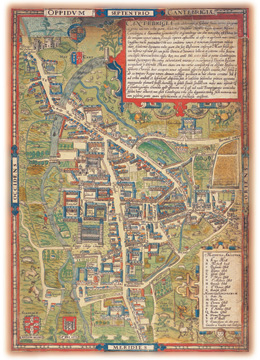 The earliest printed map of Cambridge, England, by Richard Lyne, published in London in 1574. One of only two copies of the map known to exist, it was found in 1894 by an English gentleman, pasted into the back of an atlas, and he gave it to the university in the other Cambridge. The map shows a small college town surrounded by agricultural activity. John Harvard's college, Emmanuel, founded in 1584, has not yet been built. The buildings are drawn in a vertical exaggeration common to maps of the time.
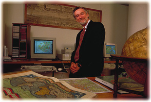 David Cobb, head of the Harvard Map Collection. Before him are a 1570 atlas, a modern street map of Moscow, a book of satellite photographs (showing topographical features on Earth that look, one is astonished to note, just as they do in maps), and an 1810 globe by the first American globemaker, James Wilson. Behind him are computers on which one may see or make new-fashioned maps, and above them hangs a salute to traditional cartography, a 1589 map of Regensburg on the Danube. The collection, open to the public free of charge, is a rich resource. Photograph by Jim Harrison