|
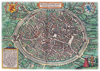 Two years after Ortelius published his world atlas (see the opening image), editor Georg Braun and engraver Franz Hogenberg began to issue their splendid (if somewhat fanciful) six-volume atlas of the world's cities, Civitates Orbis Terrarum. From volume one, published in 1572, comes this view of Bruges, Belgium, showing with fair accuracy, Cobb believes, the medieval city's fortifications, the layout of its streets, and the look of its principal buildings. Braun and Hogenberg, like Ortelius, worked in Amsterdam, then the center of cartography in Europe. They employed various artists, each of whom produced bird's-eye views. Many of the mapmakers also showed the natives' mode of dress.
|

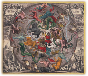 The heavens, mapped by Andreas Cellarius, Dutch mathematician and geographer. This is from a 1708 edition, published in Amsterdam by Peter Schenk and Gerhard Valk, of Cellarius's celestial atlas, Harmonia Macrocosmica, of 1660. Scientifically inclined citizens wield star locaters and surveying gear in the margins. The atlas is best known for the way certain of its maps graphically portray the astronomical theories of Ptolemy, Copernicus, and Tycho Brahe. Curator David Cobb describes this map as "a magnificent example of work from the golden age of Dutch cartography, the seventeenth and eighteenth centuries."