While the world rallies resources for relief work in Haiti, news reports have drawn attention to the need for medical supplies and food. But as relief workers try to plan the fair and efficient distribution of aid, they face another vexing challenge: the scarcity of up-to-date, accurate geographic data.
Getting new, post-earthquake satellite images is difficult enough; in addition, aid workers had trouble finding basic geographic information predating the quake. Maps showing streets, buildings, rivers, and lakes were lacking.
Enter Harvard’s Center for Geographic Analysis (CGA). After the 2008 earthquake in China’s Sichuan province, the center created an Earthquake Geospatial Research Portal, a web page for sharing maps and other information; they used this as a model to create a new resource page the day after the Haiti quake.
“The morning after the earthquake, I started looking around to see what data were available,” says CGA research manager Merrick Lex Berman. “It turned out to be pretty difficult.”
For some unknown reason, maps previously provided on the United Nations website were no longer available; Berman could not find either hydrography or basic digital elevation data. (He is still seeking these types of maps, as well as detailed street maps for some parts of the country. He asks anyone who may be able to help to contact him at 617-495-2451 or mberman@fas.harvard.edu.)
Getting recent satellite images was easy enough, but the images cannot be used in their raw format; they must first be “georectified”—processed so they match the coordinates of existing maps of the same area, so the maps can be synchronized and superimposed onto one another. Jeff Blossom, a senior geographic information systems (GIS) specialist at the CGA, performed this work, and the center brought sufficient server space online to host and transmit data-rich map files.
Then, on January 14, two days after the earthquake, Berman discovered that Talbot Brooks, a professor affiliated with the Center for Interdisciplinary Geospatial Information Technologies at Delta State University in Mississippi, possessed a satellite map with a resolution of 50 cm—“basically the highest resolution you can get with a satellite,” says Berman. The map was findable with a Google search, but couldn't be downloaded; Berman provided space on Harvard’s server for this and other datasets Brooks had.
The next challenge: figuring out how to make the data accessible to people working in Haiti, where a reliable high-speed Internet connection is now virtually nonexistent, and even a reliable power supply can be hard to come by. On January 15, Berman heard from a Boston University delegation planning to travel to Haiti. Led by Jean-Lucien Ligonde, a businessman in the Boston Haitian community, the group included assistant professor of city planning and urban affairs Enrique Silva; lecturer in city planning Anuradha Mukherji; and Elisabeth Coicou, a master's-degree student in city planning. The group would be working directly with the country’s Service National Gestion de Risque et Désastre, the government ministry in charge of the relief effort, while two other BU professors—Magaly Koch, a geologist affiliated with BU’s Center for Remote Sensing, and Sucharita Gopal, a professor in the department of geography—would lead the analysis team back in Boston.
Because the team would be involved in conducting damage assessment and planning reconstruction, it was crucial that those in Haiti have access to detailed maps, says Berman. “There’s going to be a lot of aid money coming in,” he says. “It’s important that it not get wasted.” Among other things, he says, “they want to make sure they aren’t rebuilding on top of the worst fault line.”
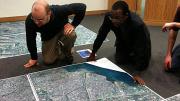
With the BU group’s departure looming, CGA staffers worked over the weekend printing high-resolution, color wall maps on the CGA's large-format printer. The delegation left January 18 as scheduled, maps in hand. (A duplicate copy of one of the maps is on display at the CGA office at 1737 Cambridge St.)
Meanwhile, CGA staff members are still adding data to the center’s site. The online resources are open and available to anyone who wants them; by January 14, the center had already received inquiries from FEMA (the Federal Emergency Management Agency) and the U.S. Coast Guard.
Berman said CGA staffers had the opportunity to go along to Haiti, but believed their expertise would be put to better use in Cambridge, where they can support sending and receiving data to and from those on the ground: “We’re just going to act as a clearinghouse.”
See this article for background on the Center for Geographic Analysis.


