


Within the United States, coastal areas host the densest populations—and are also the most vulnerable to climate change. Rising seas and intensifying storms are just the beginning, say planners at Harvard’s Graduate School of Design (GSD), who expect climate change to “ultimately transform the cultural landscapes, housing, transportation, public services, and economies” of coastal communities, according to a newsletter from the GSD’s Office for Urbanization. The School of Design is engaged in a multiyear climate-adaptation project exploring potential impacts to one exemplary coastal region of Massachusetts: Cape Ann, a rocky peninsula 30 miles northeast of Boston that includes the city of Gloucester. As part of the project—undertaken in collaboration with the Cape Ann Climate Coalition, TownGreen 2025, Water Alliance, the City of Gloucester, and the Town of Manchester-by-the-Sea—the GSD is hosting a series of talks on strategies for adapting to climate change.
The first in these “Cape Ann Conversations” was an April 5 presentation by Kerry Emanuel, an MIT professor of meteorology emeritus and one of the world’s foremost experts on hurricanes. His research group has developed methods for estimating current hurricane risk and predicting how that risk might evolve. He began his talk by recounting the history of the most powerful hurricanes to strike New England, from the great colonial hurricane of 1635, which was unusual even in the collective memory of Native American oral history at the time, to Hurricane Bob, the 1991 storm that was one of the costliest to hit the region. These storms originate in warm, tropical waters—as they advance north, they pack powerful winds that spin counterclockwise around the storm’s center, or eye. The blow can pile the water up, he said, like a tsunami, pushing the sea far inland, flooding south-facing coastal communities. Downtown Providence, Rhode Island, situated at the top of Narragansett Bay, for example, has been completely inundated more than once.
On average, these tropical cyclones have hit Cape Ann every seven years. The strongest of them, Emanuel noted, are also the fastest-moving, easily capable of traveling from just off the coast of Georgia to inland New Hampshire in a single day.
The hurricane of 1938, “probably the last in history to strike with no warning” (because prediction has improved), was particularly devastating. In 24 hours, it raced from coastal Florida to Vermont at 60 miles per hour. A weather observatory atop Blue Hill in Massachusetts recorded peak gusts of 186 miles per hour; a 50-foot wave was recorded near Gloucester. “Almost 700 people were killed,” he noted, and the inflation-adjusted damages, including the loss of 3,000 boats, two billion trees, and railroads, bridges, powerlines, and roads, totaled $9 billion. “Electricity,” said Emanuel, “was not restored for months in some areas.”
But in the case of hurricanes, history alone is not a good guide for estimating current or future storm risk, Emanuel emphasized. First, major storms have been too infrequent in New England—the data too sparse—to establish accurate measures of past risk— “And almost all the damage,” he said, “is from the very infrequent storms.” Unfortunately, “rare events are hard to predict,” and “climate change has already altered the underlying risk,” he observed. “People say climate change is about the future. No, the risk has already changed.” Fed by warmer ocean surface temperatures, hurricanes produce more wind and carry more moisture than in the past. And they drive storm surges that are more devastating because global sea level is higher.
For example, the risk of a devastating rainfall like the one that flooded Houston in 2017 during Hurricane Harvey was estimated by three independent peer-reviewed scientific studies to have tripled since 1970. Yet almost all the risk estimates used by the insurance industry “and by governments are based on storm history. This is very dangerous,” said Emanuel. He has been a “vocal advocate for getting away from history as the sole means of estimating risk,” and for using an “understanding of hurricane physics to help assess storm risk.”
New England in particular may have developed a false sense of security, abetted by a “hurricane drought” that began in 1955 and lasted until about 2000. This slowdown in North Atlantic hurricane activity, he noted, was caused by rising sulfur dioxide emissions in Europe, which have a cooling, reflective effect. When governments here and abroad curtailed those emissions, hurricane activity resumed its former track of gradually increasing frequency.
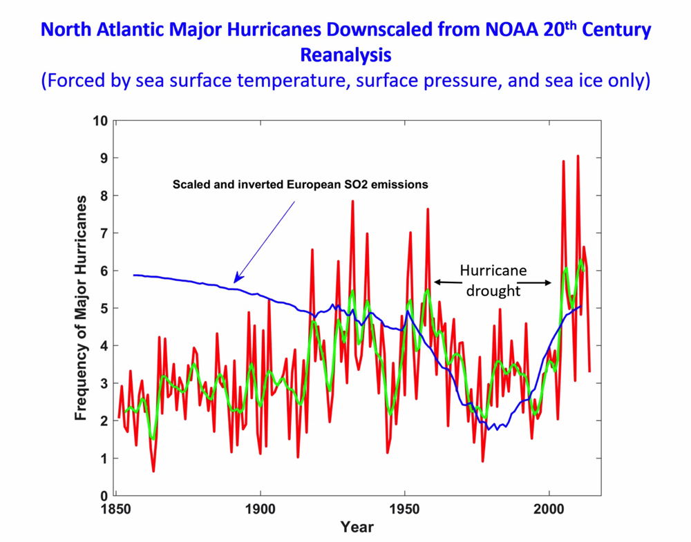
North Atlantic Major Hurricanes Downscaled from NOAA 20th Century Reanalysis (Forced by sea surface temperature, surface pressure, and sea ice only)
Courtesy of Kerry Emanuel
The ability to predict the weather has improved steadily during the past 40 years, said Emanuel, “to the point where a seven-day forecast today is nearly as accurate as a three-day forecast was in 1980. That’s a spectacular improvement.” In parallel, the ability to predict hurricanes has improved dramatically.
Starting with observations of hurricanes in the North Atlantic (the best such storm data in the world) researchers use an MIT-developed risk assessment model that “seeds” each ocean basin with large numbers of weak, randomly located cyclones. Most of these virtual seeds die because they are in the wrong environmental conditions: too much wind shear or cold water will kill the cyclones, which are assumed to move with natural atmospheric flows. Then, running a hurricane intensity model for each cyclone, scientists note how many reach tropical-storm strength. And by examining the small number of surviving events, they can develop storm-probability statistics. Based on history alone, what the models predicted for Gloucester for the period from 1985 to 2014 is a tropical cyclone every 113 years, in line with historical observations. What they predict for the period from 2071 to 2100 is a substantial increase in frequency, to every 24 years. These predictions come with a commensurate (but very low probability) increase in the maximum possible wind speed, from a range of about 105 to 115 miles per hour historically, to about 125 to 160 miles per hour in the forward-looking model, which assumes that greenhouse gas emissions continue unabated.
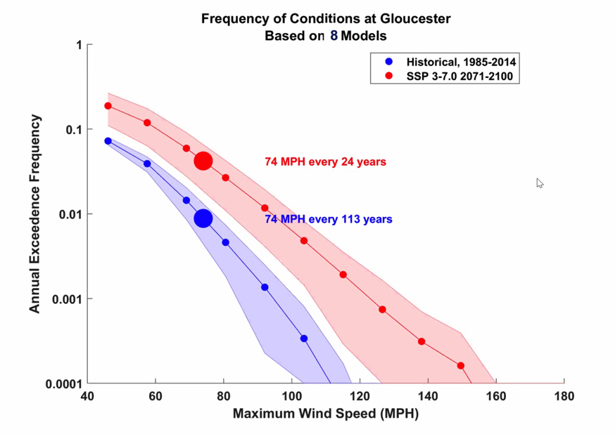
Frequency of Conditions at Gloucester Based on 8 Models
In a question-and-answer session following his talk, Emanuel emphasized that “all climate change is local,” so that what is true of New England may not be true of Florida or some other part of the world. For example, in New England, the strongest winds lie to the east of a hurricane’s track, while the heaviest rains fall at the center and to the west. This is not the case in the South. And while the intensity of storms as measured by satellites is increasing, the frequency of storms globally is expected to remain steady. But not in New England: because hurricanes have begun forming farther north, the frequency of such storms is projected to increase in places like Cape Ann.
Emanuel was asked many questions about how insurers, governments, and communities assess storm risks. He noted, first, that the catastrophe-modeling industry, a “quasi-monopoly” with only two big players globally, relies principally on historical statistics. The industry provides data to insurers, to the rating agencies that assess whether insurers have enough capital to cover their potential losses, and to the government regulators who oversee them, making it very difficult to change the system. “But it is beginning to change,” he said. He pointed out that as a consequence of this lagging risk assessment, coastal property owners don’t pay anywhere near what they would for flood insurance if the true risk were incorporated in their premiums, which in many places, would “go up by a factor of 10.” Those rates haven’t changed as much as they should, because, in effect, people who live near the coast are being “subsidized by people, typically poor…who live in less risky inland places.”

Kerry Emanuel spoke about hurricane risk in New England
Screenshot by Harvard Magazine
Second, community decisions about how to adapt to a changing climate are greatly influenced by the timescale being considered. He recounted how he worked with Dutch engineers to assess the cost of building storm barriers to protect New York City from big storm surges, versus the cost of hardening low-lying properties and buildings, raising them, and constructing dikes. What they found was that “on a 30-year timescale it is much more economical to harden buildings,” while on a 70-year timescale “it’s more economical to build storm barriers.” But there is a third option, Emanuel pointed out, “which is to mitigate climate change itself.” And if the combined cost of protecting Cape Ann, New York City, Tokyo, and other communities around the world is greater than mitigation, “maybe we ought” to pursue that.
“My feeling,” he concluded, “is that the more people can come up with good quantitative estimates of their own climate risks, the better position they will be in to make decisions, whether it’s what to do on a community level, or how much pressure to exert on governments of the world to stop climate change in the first place.”
Next in the “Cape Ann Conversations” series will be a May 10 presentation on financing climate adaptation by Jesse M. Keenan, associate professor of sustainable real estate at Tulane University, in New Orleans—a city that knows plenty about the horrific damage hurricanes can inflict. Keenan formerly served as area head for real estate and built environment at the GSD, and as a fellow of science, technology, and public policy at the Harvard Kennedy School.
These talks are part of a larger GSD program run out of the school’s Office for Urbanization, which is directed by Irving professor of landscape architecture Charles Waldheim. Research associate and lecturer in landscape architecture Kira Clingen has been leading the project, which has for the past three years been exploring the vulnerabilities at Cape Ann as a series of case studies. Working in collaboration with local community groups and governments, the effort has been assessing a variety of strategic responses to local climate change impacts, ranging from carbon mitigation to resilience planning and adaptation.